Visit my personal gallery at
Gardner Photography
for larger high resolution waterfall photos
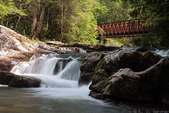
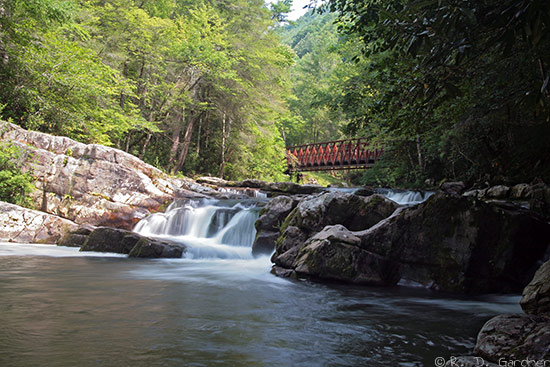
Whitetop Laurel Falls
(8/07/2007, 50 mm, f/22, 1/2 sec, ISO 100)
Description
Whitetop Laurel Falls wasn't that impressive in and of itself, but combined
with the Virginia Creeper Trail setting and picturesque bridge in the background
I had to give this waterfall a solid 5 rating.
Whitetop Laurel Creek drops a total of 15-20 feet here on its way down the
mountain towards Damascus, VA. Access is via the
Virginia Creeper Trail by hiking,
biking, or horseback. Between Whitetop and Damascus,
Virginia, the Creeper Trail follows several cascading mountain streams that can
be quite photogenic at times.
From Damascus, VA, take US-58 East for around 4 miles. Unfortunately I
was winging it and didn't get the GPS coordinates for where I parked. It
was an unmarked pullover on the right side of the highway big enough for 3-4
cars and directly next to a Creeper Trail trestle for easy trail access.
From this parking point it is about 0.5 miles on up the Creeper Trail.
There is also a designated parking lot with toilet at:
N 36° 38.640 W 081° 44.375
However, this parking lot is past the waterfall and increases the distance to
the waterfall to around 1 mile.
Hike Details
The hike or bike ride is on the Virginia Creeper Trail, an old railroad bed
that has a very gradual grade and is well maintained. Total distance
depends on where you park.
Photo Tips
The stream is wide here and offset from the waterfall there is a nice, red
bridge in the background so normal composition will be landscape.
Use a
polarizing filter for sure to help with
glare on the water and red bridge.
Part of the area will probably be exposed and bright from sunlight. I
found my Canon to be overexposing a bit so I adjusted the exposure to -0.3.
Even then I had to tone down the glare on the rocks and waterfall in post
processing using Photoshop. It was manageable, however, and the light on
the red bridge was nice.
Yes, I think a
tripod
is necessary unless you visit in the Spring and there is heavy flow. Even
then I would use a tripod.
Ok, where to shoot. Options are few and maybe fewer in the Spring when
water levels are higher. I was able to climb down the rocks to the left
side and had a relatively flat ledge on which to shoot at water level. It
worked out nicely with the bridge in the background. it's probably the
primo spot although I honestly didn't look further.

New! Comments
Have your say about what you just read! Leave me a comment in the box below.