Description
This waterfall (often misspelled as Ramsey Cascade, even on the official
national park website) is considered by some to be the best waterfall in the
Smoky Mountain National Park. I can't comment on that since I haven't been
to all of them, but I can say that it is a great hike and at the very least a
very good waterfall.
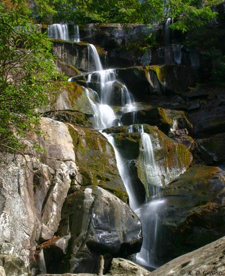
As the name implies the falls is actually a series of cascades that drop a
total of 65 feet. At the bottom, Ramsay Prong levels out, flowing over the
smooth bedrock for 100 feet or so before dropping another 15 feet and continuing
down the mountain. All of my pictures were taken above the 15' drop as I
had to stay close to my boys and well, to be honest, I forgot to go down there.

There is a massive boulder as you approach the cascade that is perfect for
relaxing and eating lunch while soaking in the beautiful scene.
Does it get any better than this? Not much.
Getting There
Ramsay Cascades can be found in the Greenbrier area off of U.S. 321.
From Gatlinburg you will drive east for about 6 miles and turn right on
Greenbrier Rd. Follow this road (turns to gravel) back into the hills,
past the picnic area, hugging the side of the mountain, and take a left on
Ramsay Prong Rd which quickly crosses a bridge. Continue about 1.5 miles
to the parking area at the end of the road. The morning we were there, we
saw several wild turkey on Ramsay Prong Rd.
The trail is at the back of the parking area.
Hike Details
This hike is not for the faint of heart. Literally.
But then again my 5 year-old did it. To be fair, though, I never
doubted his ability because he's one of those "bundles of energy" types.
Just know your limitations and the abilities of everyone else going.
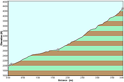
It's 4 miles uphill to Ramsay Cascades and 4 miles downhill to the car. I've
seen several different estimates on the elevation gain. Based on the
topo map, it looks like the parking area is at about 2,080 feet for an
elevation gain of ~2,200 feet overall. I'll try to generate a profile of
the trail and post it. Here it is:
The trail begins by crossing the Middle Prong on a long, wooden footbridge.
For the first 1.5 miles, the trail is an old logging or access road that is
broad and easy to walk - well, except it's uphill of course. After 1.5
miles, it looks like the trail forks. It doesn't. It's just a circle
where there used to be a turnabout. On the back side of the circle will be
a sign and the continuing trail.
The scenery from here on just gets better. Your travels will take you
through some very old forests with trees of record and near-record proportions.
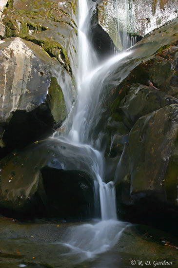
You will also get to enjoy a couple of creek crossings courtesy of log bridges.
I've included a picture of one crossing on the left.
The trail will get steep and rocky towards the end but don't despair.
The reward is worth the effort.
|
FREE TIP:
There are reports of another cascade above
Ramsay Cascades that is almost as large. I didn't know of it at
the time. Look for an unmarked trail that leads on up the
mountain. It's supposed to be about 1 mile past the main cascades.
Good luck. |
Photo Tips
I got to Ramsay Cascades too late.
I was unable to get the long shutter speeds that I would normally prefer for
this type of waterfall due to the direct sunlight. Because of the hike
length, though, your choices are limited. Your best bet is to go to the
cascades on an overcast day and/or wait for a passing cloud. Of course I
had a beautiful, cloudless sky.
I'm really not complaining.
No, really.

A polarizing filter is vital for good
pictures here to reduce the glare on the dark rocks. And as always, a tripod is a must.
Try some tight compositions with only parts of the cascades. The shot
above was taken directly on the trail as you approach the waterfall, and the
other photos were taken on the right side of the stream. A wide angle lens
will be your friend here, but you might want to try a longer lens if playing
around with tight compositions.
The water flow was low so I had no problems crossing the creek right below
the main cascades. Under high flow conditions it may be tricky as the
rocks are slick.
Return to top of Ramsay
Cascades


New! Comments
Have your say about what you just read! Leave me a comment in the box below.