Visit my personal gallery at
Gardner Photography
for larger high resolution waterfall photos
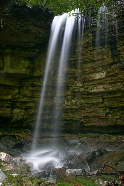
Kiner Creek Falls
(5/6/2006, 27 mm, f/29, 15 sec, ISO 200)
Description
This nice little waterfall is located about 1/4 mile past
Laurel Run Falls out of... you guessed it,
Laurel Run Park. Many people miss this waterfall because there is no
clearly marked trail to it at this time. More on that below.
On its own merit this waterfall might not rate a 2 mile hike, but combined
with Laurel Run falls (which you pass on the way up) this is a great outing.
Kiner Creek has a very small watershed so don't expect much flow in the
summertime. My visit was on May 6th and we had a decent rain a couple of
days earlier. From the picture you can see that Kiner Creek Falls may all but
disappear in the hot, dry months.
Even so, if you visit Laurel Run Falls a short hike up Kiner Creek is a
no-brainer.
Kiner Creek Falls is located in a very secluded grotto. The approach is
up the creek, literally, and as you near the falls, the climb goes over and
through rocks and debris until you suddenly emerge into the grotto.
I thought it was pretty cool.
Getting There
Laurel Run Park is located just to the west of Kingsport, TN.
Directions can be obtained from this
website on
Tennessee vacations. It is well marked with signs at every
intersection. Take 11W west out of Kingsport and turn left at the traffic
light on the other side of Church Hill. There will be a sign. After
turning, the road will cross the Holston River. Look for another sign and
turn left. After that, the road will loosely follow the river to the park.
There may be one more intersection where you should bear left.
Hike Details
First you hike to Laurel Run Falls.
The trailhead is at the back of the park.
Essentially, find Laurel Run Creek and follow it.
Don't follow the marked trail!
Ok, that sounds weird but it's true. Your best bet is to follow the old
access road along the creek when leaving the park. The trail will
eventually tie back into the larger path after doing some excessive up-and-down
stuff.
Don't worry, you can't get lost. You're just following the creek after
all.
There are a couple of stream crossings. I was told that wading would be
required. Under higher flow conditions I would agree. The day I
visited, my sons and I were able to take the first crossing on an old 1x8 board
and the second crossing was done by rock hopping.
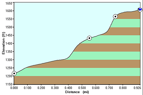
The elevation gain on the hike to Laurel Run Falls was gradual and not
excessive. See the hike profile below.
The hike is through a very pretty area, quite reminiscent of the Great Smokey
Mountain National Park. Rhododendrons abound on this hike so it's
especially pretty during their bloom.
Ok, you've stopped at the first waterfall and taken some incredible photos.
Now you're ready to find Kiner Creek Falls.
Get back on the trail and head on up the trail. At the switchback you
will see Kiner Creek right in front of you. Cross the creek here and
continue on by following the creek. The dense rhododendron underbrush has
been partially cleared for what looks like a rough trail along the bank.
Follow it up to the waterfall. This leg of the hike is short, maybe 1/4
mile or less with an additional elevation gain of about 80 feet.
Photo Tips
Not so fortunate this time, the sun caused problems the day I was there.
Morning would be the preferred time to visit and photograph. Late
afternoon/evening would be ok. I was there around 4:00 pm. Not good.
In general the grotto and waterfall are secluded and well protected by the
steep terrain. In fact there is an abundance of wet weather foliage -
mosses, ferns, and other lush groundcover around part of the grotto. But
the grotto is like a hole with no protection directly overhead. I had to
wait for clouds to pass in front of the sun to take pictures. And with
long exposures this can be tricky.
Also, there is little room to back up and take a picture. Expect to use
a wide angle lens.
As with many waterfall without a
tripod
you will be sorely disappointed in how your pictures turn out. In this
case a long shutter speed helps make Kiner Creek Falls look bigger. I
would recommend at least a 5 second shutter speed.

New! Comments
Have your say about what you just read! Leave me a comment in the box below.